Graphic of Women with Cloud above her head and word 'stormwater'

Flooding: Frequently Asked Questions

How does flood control work?

Flood control in South Florida is a shared responsibility and is achieved through an interconnected, three-tiered drainage system. Neighborhood drainage systems, or tertiary systems, are operated by property owners or residential associations. Secondary flood control canals are operated by the Lake Worth Drainage District, and primary flood control is provided by the South Florida Water Management District. Neighborhood drainage systems are designed to retain water in swales and onsite retention ponds. With prior authorization from the Lake Worth Drainage District, excess stormwater may be discharged from neighborhood systems into District canals through control structures with fixed or operable weirs to prevent flooding of property.

I have standing water is my driveway, is this considered flooding?

Since the mid-1970s, development standards for drainage systems have been regulated through design and permitting to ensure flood protection. Average rainfall will flow into onsite stormwater retention ponds through swales and drains. During heavy rain events, systems are designed to protect house floor pads. Temporary flooding of streets, sidewalks and driveways is expected and is part of the drainage design. These low-lying areas will hold back stormwater keeping it away from homes.

Who do I call if I experience flooding from a storm or natural disaster?

If your neighborhood is part of a residential association, you should contact your property manager or board first. In many cases these individuals and LWDD have already communicated about conditions. Other property owners can contact the local government responsible for ensuring that ditches and canals are adequate, clean and functioning properly. This may be the Lake Worth Drainage District, your local municipality, Palm Beach County or the South Florida Water Management District. Before storm season, property owners should have the name and contact information for this entity easily available.

What is the Lake Worth Drainage District’s role in flood protection?

  • Working with local governments and residential communities during and after a storm to provide emergency discharge of excess stormwater.
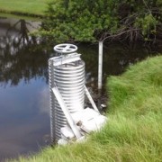
  • Operating and maintaining more than 20 major and minor water control structures
  • Permitting drainage infrastructure discharging into LWDD canals.
  • Maintenance of approximately 500 miles of canal and 1,000 miles of rights-of-way for the free flow of water and emergency access
  • Assisting local governments in emergency response during disasters, when called upon.

How do stormwater ponds help reduce flooding impacts?

Stormwater ponds help control flooding by slowing down stormwater surges and absorbing rainwater before it reaches properties. They provide for the control rate of drainage through discharge control structures or weirs. They also help filter out nutrients and sediments collected by storm water as it runs over the ground before pollutants reach fragile waterways.

Who is responsible for maintaining my neighborhood stormwater pond?

Maintenance of private stormwater systems is the responsibility of the developer or homeowners association. You can find out who owns and maintains stormwater areas by visiting the Property Appraiser’s website at www.pbcgov.org/papa and searching for the parcel and its owner. Permits and design plans for a community’s drainage system can be obtained through the South Florida Water Management District. They offer an online permit search on their website at www.sfwmd.gov/permitting.

What can I do to reduce the potential of flooding?

  • Report clogged culverts or slow-moving water in canals or swales to your property management company or responsible local government. Report issues when you see them to allow adequate time for maintenance or repairs before a storm.
  • Keep grass clippings and other debris out of stormwater drainage systems to prevent clogging and loss of stormwater storage and treatment capacity.
  • Clean out rain gutters and extend downspouts at least four feet from structures. Direct the discharge away from canals to avoid washouts in canal banks.
  • Become informed and learn more about what to expect and how to protect your home and sign-up to receive our newsletter at our website lwdd.net. The monthly publication contains articles on important public safety topics like water management, quality and quantity.

Can the Lake Worth Drainage District control water levels in canals for flood relief?

Yes. Water levels in canals are monitored and control structures flood gates may be opened to release excess stormwater for flood control. However, control structures must operate to ensure sufficient water is released for flood control without letting so much water go that we threaten the stability of the underground aquifer and municipal wellfields. While the Lake Worth Drainage District operates control structures within its canal system, it does not control flood control discharge points which are managed by the South Florida Water management District.

Does flooding occur only during hurricanes?

No. Flooding may be experienced when we receive extreme volumes of rainfall in a brief period and rainfall exceeds the water management system design. Flooding may also occur when culverts and storm drains are blocked with materials and vegetation which slows down drainage. It is important to note that you do not need to be in a designated flood zone to experience flooding. If rainfall is severe or the free flow of water is hampered, flooding can occur miles inland from a canal or other waterbody. Residents should be aware that flood insurance is not automatically part of the homeowner policy. The choice to obtain flood insurance is a personal one and should be discussed with your insurance agent. Flood insurance information can be found at www.floodsmart.gov.

If you have additional questions, please do not hesitate to contact us at 561-498-5363 or info@lwdd.net for more information.  

Community pond weir

Weirs Are Weird But Needed

In coordination with the South Florida Water Management District permit, the Lake Worth Drainage District (LWDD) allows two types of discharge control structures in residential communities and commercial properties – Operable and Non-Operable. The labels Operable and Non-Operable do not pertain to the structure’s ability to provide flood protection, but rather identify the type of structure and the way it is designed to function.

Non-Operable Structures, also known as ‘passive structures’, typically have an overflow weir or a triangular “bleed down” orifice installed at the stormwater pond’s designed water-control elevation. These overflow orifices allow the gravity flow of water through the structure and into drainage canals until the pond water rests at the designed water-control elevation. Given its passive nature, water will flow through the structure virtually any time there is rainfall except during very dry conditions when pond levels are lower than the water-control elevation.

So, why are there Operable Structures? A series of normal rain events can sometimes raise the level of the stormwater pond faster than the Non-Operable Structure can remove the water. The Operable Structure includes the passive flow described above, as well as a vertical slide-gate with an operating mechanism (usually a hand-wheel) that can be manually opened or closed to control the rate of water flow from the pond to drainage canals. The Operable Structure can be opened to manually lower the pond elevation after a rain event or before major weather systems like tropical storms or hurricanes.

It is important to note that the Operable Structure can only be opened with permission from LWDD. Sometimes that permission is granted at the request of an individual community or business. However, more often LWDD will give blanket permission to all communities and businesses based on forecasted weather conditions. In those situations, LWDD will provide notification by email and give a specific time to operate the Operable Structure. Communities and businesses can register designated representatives to receive these notification emails as well as find additional information and guidelines for the operation and maintenance of structures at https://lwddnet.wpengine.com/property-managers-hoa.

LWDD is the only drainage district in the State of Florida that allows Operable Structures.  It requires close coordination with local and regional authorities, but we believe it provides flood control benefits to the residents living within the LWDD boundaries.

1900's photo of dredge in canal

The Orrin Randolph Plan

The Lake Worth Drainage District (LWDD) was established on June 15, 1915, with a three-member Board of Supervisors whose mission was to reclaim land within its boundaries. Prior to the creation of LWDD, a considerable amount of drainage work had already been completed by several entities such as the State of Florida, the Palm Beach Farms Land Company, the Model Land Company, and the Boston & Florida Atlantic Coast Land Company. In addition, private landowners and farmers had dredged drainage canals throughout the area. Although small drainage systems had been created, a cohesive long-term drainage plan was needed for the future expansion of what is now known as Palm Beach County.

In the spring of 1916, Orrin Randolph, Chief Engineer for the newly created LWDD, presented his first report to the Board of Supervisors. This report contained 127 pages detailing a plan of means and methods for draining the lands within the boundaries of LWDD. The report was submitted in compliance with Chapter 6458 of the 1913 Session Laws of the State of Florida. At that time, LWDD consisted of 129,317 acres of land and 3,400 acres of water. Rectangular in shape, LWDD extended 26 miles in length and 8 miles in width. Population records of 1916 showed there were approximately 6,500 owners of property within LWDD’s boundary making the average ownership equal to 20 acres per capita. Approximately 400 farmers were cultivating an estimated 5,000 acres of land, principally vegetables for distribution to northern markets.

In his report, Orrin Randolph identified the areas within LWDD that could not safely be relied upon for agricultural purposes and outlined the design parameters needed for future drainage. Randolph stated, “Provisions for artificial drainage would absolutely be necessary in order to provide a run-off rapid enough to prevent the destruction of crops as a result of accumulated excess water on the land.” Thus, Randolph’s extensive report was adopted by the Board of Supervisors as the Plan of Reclamation. The implementation of this plan would forever change the local landscape.

South Florida’s abundant agricultural resources served as the catalyst upon which prosperous and populous cities were built. This prosperity, then and now, is a result of the water management plan introduced by Orrin Randolph and adopted by LWDD over a century ago as the Plan of Reclamation. This plan created a large network of drainage canals providing flood control and water supply which remarkably still functions today for over 800,000 residents and tens of thousands of acres of farmland.

Agriculture in our area no longer exists to only feed the local inhabitants, and the migration of people into Florida continues to increase annually. LWDD has modified its mission over the century to meet the changing water management needs of these two diverse communities. Much of the District’s emphasis today is on residential flood protection. Although meeting the needs of agriculture and settlement can bring many challenges, it is because they harmoniously co-exist that living and working in our community is so highly desirable.

golden retriever dog in rain boots holding an umbrella

How Flood Control Works

Man-made stormwater ponds are attractive enhancements to many residential communities and businesses within the Lake Worth Drainage District (LWDD). More importantly, these waterbodies serve an important public safety purpose as they are part of the overall flood control system.

When it rains stormwater flows into the retention pond and, if needed for flood control, out through the pond’s discharge control structure into the LWDD canal. Most of the time this drainage occurs unnoticed by the average individual. However, during a severe storm, flooding in streets, sidewalks, and driveways may occur. This temporary flooding may cause concern, but it is important to note these low-lying areas are designed as secondary detention areas to protect buildings and homes from flooding.

Within LWDD’s boundary, flood control is a shared responsibility and achieved through an interconnected, 3-tiered drainage system governed by 3 unique groups of people. Through communication and coordination, these 3 groups can provide effective flood control. The groups are identified as:

  • Neighborhood drainage systems operated by property owners or residential associations
  • Secondary drainage systems operated by LWDD or municipalities
  • Primary regional system operated by the South Florida Water Management District

Water managers in charge of primary and secondary systems are continually monitoring the weather and canal levels to proactively respond to changes in canal elevations. In anticipation of a heavy rainfall event, water managers will make operational adjustments to maintain appropriate water elevations for flood control. Additionally, throughout the year routine canal maintenance is conducted to provide unobstructed flow in the canal channel and access along the canal rights-of-way. The inspection of control structures, pumps and other infrastructure is also conducted, and repairs or replacements are made.

Property owners and residential associations have a similar role regarding their neighborhood drainage system. They must maintain their drainage infrastructure to ensure that inlets, storm drains, underground pipes, and emergency discharge control structures are free of potential blockages and working as designed, thus maintaining the flow of stormwater away from their property. An annual inspection of the drainage infrastructure should be made, and repairs should be completed before the onset of storm season.

LWDD works closely with property managers and community boards to manage potential flooding. You can find more information about flood control at https://lwddnet.wpengine.com/storm-response.

Men looking a set of blueprints

Potential Impacts of Sea Level Rise on Water Management

Excerpt From South Florida Regional Compact Implementation Guidance Series 2021

As the sea level continues to rise in response to the changing global climate, south Florida will become more and more susceptible to a wide variety of negative effects, primarily due to its very low topographic elevation. While the effects of sea level rise on coastal communities in south Florida are being reported worldwide, the more subtle impacts to the regional water resource management system, have recently come to light. The impacts fall into three general areas:

  1. Flood protection and drainage systems
  2. Quality of existing underground water supply sources
  3. Natural systems already impacted by human activity

The first, and most obvious impact is to the overall drainage system which in virtually every case ultimately releases excess stormwater into the ocean through the coastal estuaries. These systems are almost exclusively gravity driven. This means that water flows from higher elevations on the landscape to lower elevations simply by allowing gravity to pull the water from one drainage feature (swale, ditch, canal, pond, etc.) down to another until it finally flows into the ocean at the lowest level. When the ocean elevation rises, the elevation difference between upland areas and the ocean is lessened, which in turn lessens the gravitational pressure to move large volumes of rainfall runoff out to sea. This effect ultimately reduces the flow of water through the structure and slowing it down and increasing the frequency and duration of flooding resulting from heavy rains.GraphicThe path that stormwater takes from its beginning as runoff from heavy rains to its release into the ocean, is managed by a series of numerous physical structures made up of pipes, gates and sluices. These structures are operated (opened or closed) in conjunction with one another to release water from developed areas to avoid flooding or hold it back to enhance water storage and groundwater recharge.

Slow drainage problems are amplified when coastal structures are hit with a heavy rainfall event which is typical during land-falling tropical storms and hurricanes. In these cases, the elevation of the storm surge downstream of a structure (ocean side) can be pushed above the water level in canals upstream (land side). In these situations, the system operational personnel have no choice but to close the water control structure to avoid the inland rush of the coastal storm surge into the canal network, thereby further worsening flooding impacts.

Regional coastal structures maintain groundwater levels, which hold back saltwater intrusion into underground freshwater aquifers; they are also critical to minimizing flooding impacts. But numerous communities downstream of these facilities do not directly benefit from their operation yet face the same threat to their drainage infrastructure. The cities of Miami, Miami Beach and Fort Lauderdale are key examples of this situation.

Sea level has risen about eight inches over the past 100 years, and there are clear indications from recent tidal data that the rate of rise is accelerating. This forces immediate attention on the regions, like coastal south Miami-Dade County, where the current water control elevations are already very close to the current range of tidal fluctuations.

Most of the major water control structures along the coastline in Miami-­‐ Dade County already maintain canal elevations very close to the upper end of the normal tidal elevation range. In some cases, spring tides already exceed the normal canal elevation, which forces gate closures at least twice a day during those periods.

Similar situations exist in Broward County, where numerous communities and their local drainage systems are situated downstream of the regional water control system. These communities find themselves in the position of facing a double threat associated with flooding. They are threatened by both direct impacts of rising seas on their local drainage systems, and storm discharges from the western regional systems flowing through the canal systems in their communities. A simple solution would be to stop or reduce the releases from the western communities. However, this action would most certainly worsen flooding in those towns and cities.

Adaption strategies can be complicated and expensive but must be considered for future implementation Statewide. For more information on the response to sea level rise, visit  https://southeastfloridaclimatecompact.org.